 Cumberland, Maryland Mile Marker 0
How do I begin to write about this adventure...all that comes to mind is "so amazing, highlight of my year, can't wait to do it again!"
The best way I can describe the bike ride is through my GoPro video. While I don't think a 15 minute video can really do the 3 day, 150 miles and almost 15 hours of riding time justice, I will say it is a really good start to being able to share a glimpse into how "amazing" this adventure was! I'm new to the GoPro camera, so I'm still learning a lot - and need to buy a couple more accessories to make filming off the bike easier - but overall I'm really happy with how my first video turned out. It's long, but I promise it is worth watching. Volume up. 1080 HD setting is available in the bottom right of the video. Enjoy!!
P.S. here is the longer, 15 minute, version of this video:
|
|
Trip Highlights
Ok, so you're probably wondering how this trip came about? 2 years ago my friend Kylee came across an article about the Great Allegheny Passage (GAP). She passed it onto me to store away in the 'vacation file', and for a couple years it has been in the back of my mind. At first it was the "oh sure- let's do that one day...haha...not". Then slowly it turned into, "well - it might be neat to think about one year". To finally in the spring this year I emailed my friend David (#1 riding partner!) and I just said "Hey...let's actually ride the GAP this year!". And because David generally trusts my crazy ideas, he said "OK!". And so the planning began...
We decided to ride over labor day, to take advantage of the Monday off of work. Then I just started reading every article, website and blog I could find about the GAP to figure out the best planning tips for the trip.
Putting the plan together
Some really helpful websites I used are:
The planning was actually much harder than I anticipated. By figuring out the best towns to stay in (i.e. most food and lodging options) I then calculated out roughly how many miles we wanted to ride each day. Paired those two together and had the start of the rough plan. Originally we were going to start in Cumberland. The first 23 miles out of Cumberland is uphill, but then the remaining 130 miles are downhill. I booked the first night's stay in Meyersdale, and then when I was trying to find a room in Connellsville for night 2 there was nothing! Advice: book your rooms early. With so few choices in each town, they definitely fill up fast. After struggling with what to do on night 2, I finally had a thought - reverse the trip. The uphill grade is rarely more than 1.75% - so while you go up for a long time, it is definitely doable. Plus I have to say the last 23 miles downhill, dropping 1,700 feet in elevation, was definitely worth all the pain of the prior two days!!
Day 1: Pittsburgh, PA to Connellsville, PA
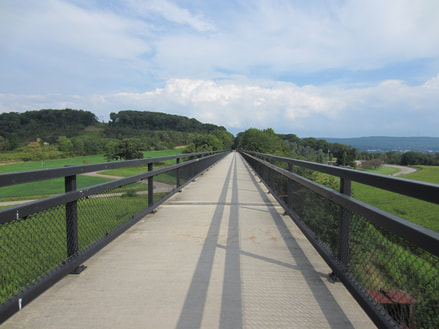
David and I picked up our bikes in Pittsburgh on Friday morning at the Gap Outfitters bike shop and hit the trail by 10am. We rode slow, wanting to enjoy ourselves and take in all the sights around us. The first day didn't have too many specific highlights to see, but never the less it was a great day. Bridge after bridge to ride over, little towns to bike through, beautiful scenery, etc.
We decided to ride over labor day, to take advantage of the Monday off of work. Then I just started reading every article, website and blog I could find about the GAP to figure out the best planning tips for the trip.
Putting the plan together
Some really helpful websites I used are:
- Great Allegheny Passage Official Website - everything you need to know and more about the GAP. Lots of great maps you can view and print.
- Bikecando Website - the Towns and Services section was very helpful to find out which towns had food, lodging, etc. You can click on each city name for a list of all the places in town.
- GAP Trail Towns - I relied on this website a lot to pick out which towns to stay in, and where to eat lunch along the trail.
- Top 10 Highlights: Great Allegheny Passage - fun to read and get excited about the things you will see along the way.
- GAP Outfitters - bike shop in Pittsburgh we rented our bikes from. Amazing store!!! So friendly and helpful. They gave us the pannier bags a day early so we could pack up our stuff the night before the ride, and spent so much time with us on the day of our ride to make sure our bikes were perfectly fit and ready to go.
- Cumberland Trail Connections (CTC) - Gap Outfitters sister store in Cumberland. Depending on which direction you decide to ride, you can rent at either store. We used CTC for our shuttle service back to Pittsburgh.
- Connellsville B&B - where we stayed on night 1, in Connellsville, PA. Great place, lovely hostess and amazing breakfast!
- Yoder's Motel - where we stayed on night 2, in Meyersdale, PA. The hostess was so great! Very good communication leading up to check in, perfect rooms, she even provided us recommendations for dinner and breakfast around town. I booked on airbnb.com, but this is the TripAdvisor review.
The planning was actually much harder than I anticipated. By figuring out the best towns to stay in (i.e. most food and lodging options) I then calculated out roughly how many miles we wanted to ride each day. Paired those two together and had the start of the rough plan. Originally we were going to start in Cumberland. The first 23 miles out of Cumberland is uphill, but then the remaining 130 miles are downhill. I booked the first night's stay in Meyersdale, and then when I was trying to find a room in Connellsville for night 2 there was nothing! Advice: book your rooms early. With so few choices in each town, they definitely fill up fast. After struggling with what to do on night 2, I finally had a thought - reverse the trip. The uphill grade is rarely more than 1.75% - so while you go up for a long time, it is definitely doable. Plus I have to say the last 23 miles downhill, dropping 1,700 feet in elevation, was definitely worth all the pain of the prior two days!!
Day 1: Pittsburgh, PA to Connellsville, PA
David and I picked up our bikes in Pittsburgh on Friday morning at the Gap Outfitters bike shop and hit the trail by 10am. We rode slow, wanting to enjoy ourselves and take in all the sights around us. The first day didn't have too many specific highlights to see, but never the less it was a great day. Bridge after bridge to ride over, little towns to bike through, beautiful scenery, etc.
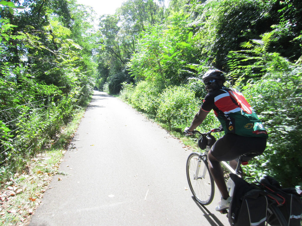
David riding the GAP trail on Day 1
|
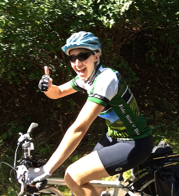
Happy while riding on day 1 out of Pittsburgh
|
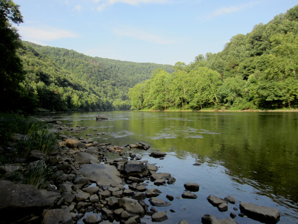
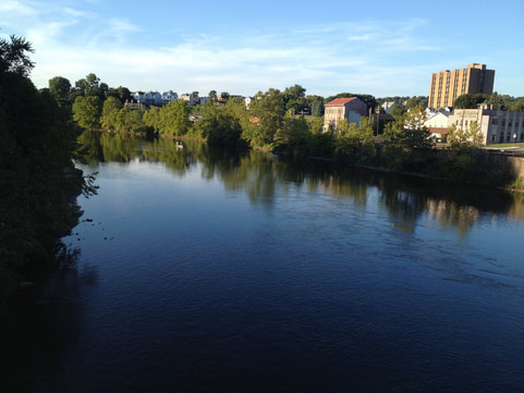 Connellsville, PA River view
We stopped in West Newton for lunch, 34 miles from Pittsburgh. We ate at a place called The Trailside, literally right off the trail. Great place to sit down, relax and refuel. Plus they were over a bike shop, so you had everything you may need. After lunch we got back on the trail and continued riding the remaining 25 miles to Connellsville. We pulled into town just before dinner time. Day 1, at 59 miles, took us a total of 7 hours, with just under 6 hours of riding time. We quickly realized that while we are used to road bikes, the combination of a trek hybrid bike and luggage over the back tire definitely slowed us down. At home we average 15 mph, but on the trail we averaged 10 mph. Not bad for a leisurely ride, but keep that in mind when planning your days. In Connellsville we checked into the Connellsville Bed & Breakfast, washed up and then went out to find cold beer and dinner! Our B&B hostess had great tips for dinner and told us of a good Mexican restaurant, El Canelo, that did not serve alcohol but allowed BYOB. So on our walk over (just a few blocks away - over this gorgeous river) we stopped in a bar she recommended, The Paint Room, that oddly enough sold us a 6-pack to go and we took it over to the restaurant. After dinner we called it a night, and were excited to see what day 2 had in store.
Day 2: Connellsville, PA to Meyersdale, PA
We woke up on Day 2, had a great breakfast at the B&B and got on our bikes by 9am. We knew today would be the hardest....almost 1,400 feet of climbing at a gradual incline all day....but the river, peaceful nature surroundings and the amazing views more than made up for the pain!
We woke up on Day 2, had a great breakfast at the B&B and got on our bikes by 9am. We knew today would be the hardest....almost 1,400 feet of climbing at a gradual incline all day....but the river, peaceful nature surroundings and the amazing views more than made up for the pain!
Youghiogheny RIver on Day 2 outside of Connellsville
|
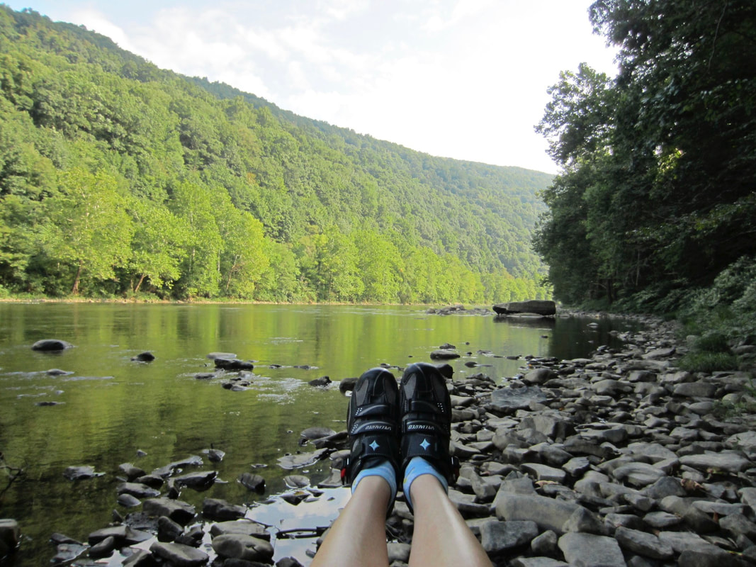
Youghiogheny RIver on Day 2 outside of Connellsville
|
|
While Day 3 has the best highlights (which I'll get to below), I really have to say Day 2 was my favorite. Riding along the Youghiogheny River all day, coming across the bridge in Ohiopyle with the most amazing view - I could have just ridden and been perfectly content for days and days! It was neat to see as we were riding how we started almost level with the river and then mile after mile the river got further away from us. The bridge at Ohiopyle was a definite highlight! I could have stood up there enjoying that view for hours.
|
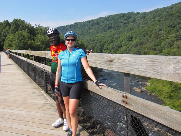
Standing on the bridge over the Youghiogheny River entering Ohiopyle
|
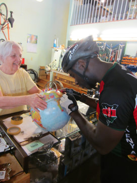 David putting his Kenya pin in the globe at the Confluence Bike Shop
We stopped for lunch in Confluence, 28 miles into our ride. When we pulled off the trail a lady was passing out vouchers for a prize at the bike shop in town. We figured why not, we would swing by there first and see what the fuss was about. David had his Kenya jersey on and the bike shop owners asked if he was from there. He was, and they got so excited. They said "you have to put a pin in our globe!" Sure enough, he stuck his pin in Nairobi and the owners took a picture of us. A nice welcome to the city. Our prizes were pretty funny - I won a postcard and David won a coupon for a free ice cream at a restaurant just across the street. The bike shop owners said the restaurant was great, so we figured we would give it a shot. It was called Sherman's Ice Cream Parlor & Kitchen. We enjoyed a really good lunch, used their free wifi (since there was no cell phone service in town), they refilled our water bottles and we were back on the trail.
|
The afternoon was more of the same - great scenery and a gradual uphill climb. Tip: if you need cell phone service and realize you don't have it (which I needed to text our B&B host for that evening to tell her what time we were arriving into town), look for the little information shed right along the trail in Rockwood. Thankfully he had a booster and within 15 feet of his shed I got service! The best part of the afternoon was riding over the Salisbury Viaduct - about 600 feet high and 1,908 feet long. It took about 2.5 minutes to cross. Unbelievable views of the town, corn fields and wind farms.
|
Riding over the Salisbury Viaduct, heading into Meyersdale, PA
|
We finally pulled into Meyersdale around 5:30pm, after 8.5 hours with 6 hours 15 minutes of riding time. We stayed at the Yoder's Motel that night - really great place. It was fairly new...unfortunately she was not getting wifi installed until the next week - and I still had no service. bummer! One note for this town - we rode down a huge hill to get to the motel, which all we could think about is that we had to go back up the hill in the morning! lol. That night we ate at the Morguen Toole Company. The history of the building is pretty neat, so you can read about it's history if you are interested. I'll admit - we mostly enjoyed the good beer and free wifi. Needless to say, we stayed for hours. The waitress was very friendly, didn't mind at all that we hung out, and proceeded to tell us a lot of stories about the town and the building. We finally called it a night, very tired after two days of riding.
|
Day 3: Meyersdale, PA to Cumberland, MD
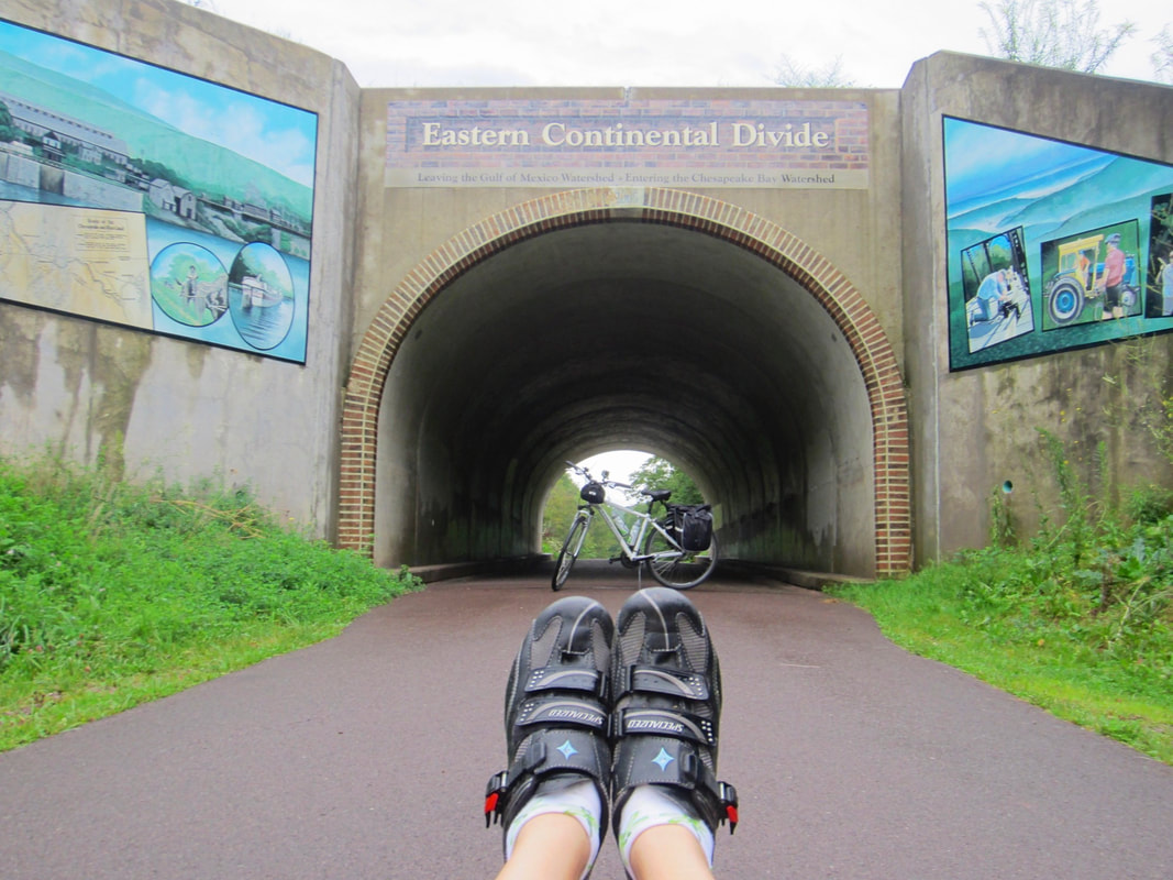
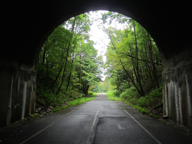
In the morning, as our motel host told us - there were a grand total of 2 places to eat breakfast! It was a Sunday and most places were closed in the tiny town of about 2,500 people. It was raining in the morning, so we picked the place right across the street - Donges Drive-In. We ran over, had a great breakfast sandwich and coffee, then headed on our way for the final day of riding. It was just barely sprinkling by the time we got on the bike and we were just hopeful the weather would hold out for us, which thankfully it did. Yes...the hill out of town was treacherous! I ended up having to walk up most of it, it was so steep. So already exhausted, we started riding the final 32 miles. This day was just really amazing - one thing after the next, it just kept getting better. The first 9 miles continued the uphill climb - just about 350 feet. And finally, before we knew it, there it was - the Eastern Continental Divide! 2,392 feet. It was a cute little tunnel, with some neat murals, but really it was just so exciting because we knew it meant the rest of the trip was downhill! We had fun taking video and photos at the divide, and then continued on our way. |
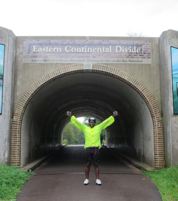
David at the Eastern Continental Divide!
|
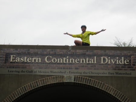
EJ on the Eastern Continental Divide bridge!
|
David at the Eastern Continental Divide!
|
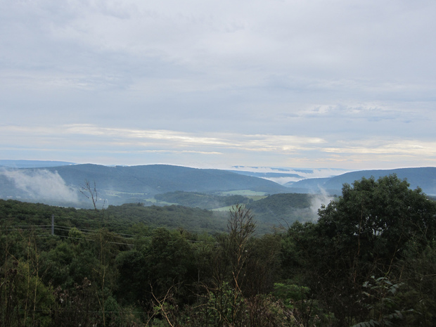
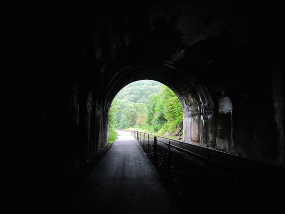
Just 2 miles later, before we knew it we were at the Big Savage Tunnel. Now this is what we had been looking forward to for months - maybe even years. We put our headlamps on (though realized later they were not necessary as it was so well lit) and entered the unknown! 3,294 feet long (built in 1911) - it took us almost 4 minutes to ride through. So so cool!!! When you emerge from the tunnel, get ready for the most breathtaking view of the rolling landscape and towns far below (my photo definitely doesn't do it justice).
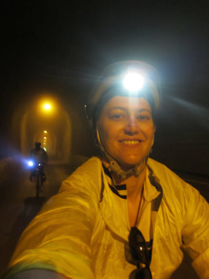
David and EJ biking through the awesome Big Savage Tunnel
|
The view as we exited the Big Savage Tunnel. Wow!
|
Just a couple miles later we came upon the Mason-Dixon line. Finally we made it to Maryland! We of course had to take pictures standing in both states at once.
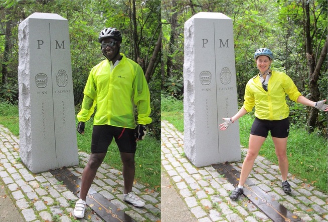
Mason Dixon Line - Standing on Pennsylvania & Maryland
|
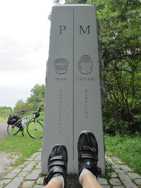
Mason Dixon Line - Standing on Pennsylvania & Maryland
|
|
3 miles later we came to the Borden Tunnel, 957 feet long - also built in 1911. Now this one got dark! And what was even more humorous - because we just kept riding and didn't stop before entering - I'm about a third of the way into the tunnel thinking - oh my gosh - I can't see anything!! Um - duh...take off your sunglasses! It helped a little, but trust me - that tunnel is dark. All you do is focus on the tiny "light at the end of the tunnel" and hope you don't hit anything!
|
Existing the Borden Tunnel
|
Biking through the Brush Tunnel
|
When we got to Frostburg the trail met up with the Western Maryland Scenic Railroad - a track that runs a Steam Train from Frostburg to Cumberland. I have to say - riding downhill with amazing views on your left and the tracks on your right - pretty breathtaking. At 6 miles until the end, we went through one last tunnel - the Brush Tunnel, 914 feet long. This one was neat because the active train track also went through the tunnel. As the sign warns - do not enter the tunnel if a train is coming!
|
I wanted a train to pass by so badly, and finally just a few miles from Meyersdale I got my wish. We heard it coming around the corner and stopped our bikes to watch it go by. Wow! Standing about 3 feet away as the steam train sped past...very neat experience. I loved that we were taking pictures of the train while the people on the train were taking pictures of us.
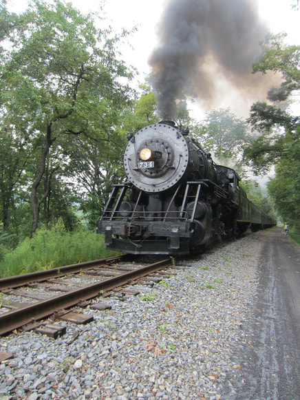
The Western Maryland Scenic Railroad - Steam Train
|
At last, we finally made it into Cumberland, 3.5 hours later with about 2 hours 45 minutes riding time. We descended a total of 1,730 feet in those last 23 miles - what a great way to finish. In town we crossed the street and came to the town center. I was searching the ground all over because I knew that GAP Mile 0 marker was in the brick somewhere. Took me a bit, but I finally found it! We rode just a few tenths of a mile further and pulled right up to the bike shop - Cumberland Trail Connections. It was almost 1pm and we had a shuttle reserved for that afternoon to take us back to Pittsburgh. We changed clothes, locked up our bikes and walked just behind the bike shop to a place called the Crabby Pig. We enjoyed lunch, we celebrated the fact that we were done, and were sad at the same time realizing our adventure was over way too fast! We sat there already planning our next trip!! The shuttle to Pittsburgh took about 2 hours and then we dropped off our bikes at the bike shop and headed to our hotel.
|
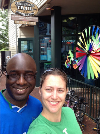
We made it! The bike store in Cumberland, Maryland
|
As you can tell - I can't say enough great things about this trip. Until next time Great Allegheny Passage! We may even attempt the additional 185 miles on the C&O Towpath next time all the way to Washington D.C. David...what do you say???
You can view more of my photos from the Great Allegheny Passage here - GAP Photos